Home   |   Contact   |   Links   |   Imprint   |   Privacy   
[Deutsche Version]  
News
Competences
Projects
All projects
Publications
About us
TCP International

Activity 1: Spatial Planning and Spatial Research - Projects

Via Egnatia: Motorway Case Study in Northern Greece (2002)


Client:  own research
Partner:  Institute for Spatial Planning at University of Dortmund (IRPUD) (Dortmund)

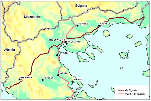
The Via Egnatia motorway located in the North of Greece is one of the most important and ambitious projects of the Trans-European transport Networks programme (TETN) funded by the European Commission. The motorway is to link the Adriatic coast in the Northwest of Greece with the Turkish border in the Northeast. Via Egnatia is not only expected to become the backbone of road traffic in Northern Greece, but should also bring areas like Epirus, Western Macedonia and Thrace out of their isolation and thereby multiply investments in industry and tourism. Moreover, Via Egnatia is supposed to enhance the geopolitical position of Greece in Europe, the Balkans, the Mediterranean Sea and the countries of the Black Sea in order to reduce disparities of regional development in Europe.
This case study assesses the likely spatial and socio-economic impacts of this motorway in a threefold, hierarchical way: Firstly, travel time reductions are assessed; secondly, impacts on potential accessibility are calculated in order to reveal changes in the locational advantages of regions as basis for their economic activities; thirdly, the impacts on regional GDP are modelled by using a simulation model for the prediction of regional GDP already developed in the framework of the SASI project.
The results show, that some of the regions in Northern Greece yield significant travel time savings (particular regions at the both end points of the motorway), which also have positive effects on regional accessibility, but to a lesser degree. However, the relative increments in accessibility in Northern Greece remain rather small unless also other motorway projects like the P.A.T.H.E. motorway are being implemented. Translating these positive effects into regional economic development, it was shown, that though Greek regions will belong to the European regions with the highest GDP gains, the related increments will remain modest due to the low start level. If these gains are standardised, it is to be expected that Northern Greece falls further behind the European average, and so regional disparities are likely to increase rather than to decrease.
Beyond these results, it has also been the objective of this case study to develop and propose the hierarchical three-step assessment framework for new transport projects. It was shown that such a framework is well suited for the assessment of infrastructure projects, yielding differentiated results with respect to the three dimensions analysed. In that, it should be used complementary to the standard CBA assessment framework.


 More on this topic
Futher Information:  Stefano Panebianco (IRPUD) or Carsten Schürmann

Related documents:  via_egnatia_presentation_networks_for_mobility.pdf

Links on the web:  Egnatia Odos A.E


Other projects in this field of competence:

Development of a system of indicators for monitoring the development of Sorbian/Wendish culture and language and their valorisation in Brandenburg (2022 - 2023)
Atlas of Industrialisation in the New Federal States (2nd edition) (2020 - 2021)
Development indicator system for "good life" for the Lusatia (2020)
TeMoRi - Territorial Monitoring update and Regional Potential Index for the Baltic Sea Region (2016)
Value-added in renewable energy sector (2014 - 2015)
Serengeti Nationalpark (2014)
ESPON Matrices (2014)
SWOT Analysis of the South Baltic Cooperation Programme 2014-2020 (2013 - 2014)
HTTransPlan - Impact Assessment of Railway Tunnel between Helsinki and Tallinn (2012 - 2013)
Atlas of Industrialisation in the New German Länder (2012 - 2013)
SUTMP Windhoek (2012 - 2013)
Service area analaysis for the City of Münster (Northrhine-Westfalia) (2012)
ESPON BSR TeMo - Territorial Monitoring for the Baltic Sea Region (2012 - 2014)
Service area analaysis for shopping centre in Düren (Northrhine-Westfalia) (2011)
LogMos II (2011 - 2014)
Assessment of Central Places in Bavaria (2010)
Study on Mountain Areas in Southern Norway (2010)
ESPON INTERCO - Indicators of territorial cohesion (2010 - 2012)
ESPON TRACC: Transport Accessibility at Regional/Local Scale and Patterns in Europe (2010 - 2012)
Regional Challenges in the Perspective of 2020 (2010 - 2011)
Status Report on the Establishment of the National Environmental Information Network Kuwait (NEIN) (2009)
TRACECA IDEA (2009 - 2012)
Western NIS (2009 - 2010)
AccBavaria (2008 - 2009)
Analysis of Nordic Labour Market Areas (2007)
Regional Disparities and Cohesion (2007)
RePUS (2007)
ESPON Accessibility (2006 - 2007)
ESPON 4.1.3 (2006)
Accessibility Analysis of the Baltic Sea Region (2006)
FUNDING Infrastructure: Guidelines for Europe (2005 - 2007)
Northern Peripheral, Sparsely Populated regions in the European Union (2005)
SETI (2005 - 2006)
AlpenCors (2004 - 2005)
FOPS 73.319: Regional Impacts of Transport Infrastructures (2004 - 2006)
ESPON 1.1.1: The Role, Specific Situation and Potentials of Urban Areas as Nodes in a Polycentric Development (2002 - 2004)
ESPON 2.1.1: Territorial Impacts of EU Transport and TEN Policies (2002 - 2004)
Mountain Study - Analysis of mountain areas in Europe (2002 - 2004)
IASON: Spatial Impacts of European Transport Policies (2001 - 2004)
ILUMASS: Land Use and Transport (2001 - 2004)
Peripherality (2000)
Supply Quality of the Retail Sector – A Modelling Approach (1999 - 2000)
Ufo Working Group: The New Main Railway Station of the City of Dortmund (1999)
Quality of Life in European Regions (1996 - 2003)

  © RRG, 2003-2023  ·  TOP