 |
|
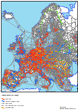
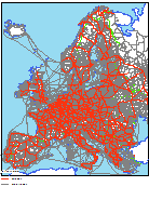
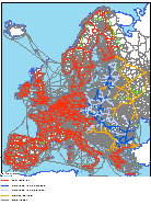
RRG GIS DatabaseTransport networks - Road networkGeneral information The RRG European road network contains all motorways, highways, dual-carriageway roads, E-roads and national roads as well as additional principal roads in agglomerations and important car ferries. Currently the road network contains some 264,000 links and 205,000 nodes. In addition to currently existing roads, the database contains all future projects of the trans-European transport network (TEN-T) programme of the European Union as specified in Decision 1692/96/EC of the European Parliament and of the Council (European Communities, 1996), further specified in the TEN Implementation Report (European Commission, 1998) and later revisions of the TEN guidelines provided by the European Commission (1999; 2002a; 2004a; 2004b), so as the revision of the TEN-T guidelines as of 2011 (European Commission, 2011a; 2011b), information on priority projects (European Commission, 1995), later publications on the priority projects (European Commission, 2002b; 2005), as well as so-called TINA networks (TINA = Transport infrastructure needs assessment; TINA Secretariat, 1999; 2002; Kartal, 2007) for the new member states and candidate countries and the Helsinki corridors for the remaining east European countries. A subset of the full road network is the strategic road network which contains the trans-European road links as specified in Decision 1692/96/EC of the European Parliament and of the Council, the TINA networks for the candidate countries and the Helsinki corridors (European Commission, 1995) for the remaining East European countries as well as selected additional links in eastern Europe and links to guarantee connectivity of regions and NUTS-3 centroids. The strategic road network is dedicated as a transport modelling network, e.g. for accessibility calculations and traffic analyses, at the European level and comprises almost half of the entire road network. The modelling subset can be distinguished from the other links via specific fields in the attribute table. For transport modelling purposes, it also contains virtual access or connector links linking the centroids of the transport zones to the network. The transport zones correspond to the NUTS-2 regions of the system of region as defined by Eurostat (Eurostat: 1995; 1999a; 1999b; 2004; 2007, 2010). The trans-European road network contains important existing trunk roads as well as planned links and roads un-der construction. Planned TEN-T and TINA links are coded with their current characteristics and reflect the situation in early 2015 (March 2015). The attribute \"planned\" means that in future some development will take place either in form of upgrading, e.g. from a national road to a motorway, or by construction of a new road or motorway. If the alignment of the planned link is known, it is assumed that the upgrading will take place along that alignment. If the future alignment is not yet known, it is assumed that the development will take place in a corridor along the coded link. In addition to the coding of the TEN-T outline plans, also other national outline plans of the European countries are coded in the road network layer. By applying this information, future road networks until 2030 may be extracted from the RRG GIS Database. Similar to the future developments, the road network layer also comprises the historic development of the road networks since 1970, which means that the development over time of the road networks from 1970 until 2030 is coded in the database. Thus, layers representing the road network for any of the years in between 1970 and 2030 may be provided. The name of the layer containing the trans-European road network is ROADxx and comprises arc (ROADARC) and node (point) (ROADPNT) feature classes. Its main characteristics are: Layer name: ROADxx Feature classes: Arcs, nodes (points) No of arc features: 263,916 No of node features: 205,185 User attributes associated with the arcs: 36 User attributes associated with the nodes: 9
Detailed description of the arc attribute table The following user-defined fields are available in the ROADARC layer for the arc feature class:
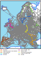
COUNTRY indicates the ISO code of the country in which the link is located. Car ferries and shipping routes (motorways of the sea) between different countries are assigned the country code \'YY\'; car ferries within a country got the standard ISO country code of the respective country assigned. LINKTYPE, LINKCAT, CODE, LANES, EURID, NATID, CONST, TRUNK, INTERURBAN, SPEEDCAR, SPEEDLOR, OPERATION and MARITIME and CONTINENTS give general information on all links. TRUNK indicates whether or not a road represents a trunk road. Trunk roads are defined as motorways, E-roads, national roads and other dual-carriageway roads. INTERURBAN indicates whether or not a road section is a urban road located within urban centers, towns and villages, with local speed limits. SPEEDCAR gives the national speed limits for cars, subject to the link category and country, while SPEEDLOR provides the same kind of information for heavy trucks. Access links have a general speed of 30 km/h. In case of car ferries, the Eurotunnel or motorail services (vehicle pick-ups in Swiss rail tunnels), SPEEDCAR and SPEEDLOR are not filled, but the field MARITIM provides the respective timetable travel times. CONST represents specific artificial buildings (constructions) along road sections: tunnels and bridges. However, only major buildings are indicated in the dataset. OPERATION indicates whether a road section is under opertation, planned or even abandoned. The field LANES indicates the number of lanes per direction. This field is a character field, separating figures for each direction by a comma. Usually, motorways and dual-carriageways have 2,2 lanes (i.e. two lanes per direction), while trunk roads, regional and local roads have 1,1 lanes (i.e. one lane per direction); however, there are exceptions from this rule. For instance, many motorways have three lanes per direction (3,3) or three lanes for one and two lanes for the opposite direction (3,2); in case of one-way roads, there are one or two lanes for one direction and no lane for the opposite one (1,0, 2,0). For ferries and shipping links, SAILING_DIST and SERVICE_FREQ provide information on the sailing distance across the waters, and on the frequency of the (ferry) services. CONTINENTS provides a flag for the continent upon which a link is located, allowing the user to select all features located on a specific continent within one step. The database covers features in Europe (CONTINENTS=5), Asia (CONTINENTS=1, parts of Russia and Turkey, Syria, Lebanon, Israel, Palestine), and Africa (CONTINENTS=2, Algeria, Egypt, Tunesia, Lybia, Marocco). TENCAT, TENALIGN, PRIOEL, PRIOEU03, PRIOVM, PRIOSEC, CORRIDORS and CATEGORY give information on those links which are included in the \'Trans European Transport Network Outline Plan, Section Road\' based on the Joint Decision of the European Parliament and of the Council published in the Official Journal of the European Communities (L228, 9 September 1996), or are part of the TINA network (TINA Secretariat 1999; 2002). The road corridors towards eastern Europe were first agreed at the second pan-European Conference of the European Ministers of Transport in Crete in March 1994 (\'Crete Corridors\') and secondly confirmed at the Helsinki meeting (now: \'Helsinki Corridors\'). The \\\'TINA road link, backbone\\\' (CATEGORY=2) are the former Crete Corridors in the candidate countries, whereas the \\\'TINA road link, additional\\\' (CATEGORY=3) represent additional links identified by the TINA Secretariat in correspondence with the candidate countries to connect important cities to the trans-European road network. Additional links of the strategic network (CATEGORY=5) are (semi-)important road links identified by RRG which are neither part of the TEN or TINA networks nor part of the Helsinki corridors (CATEGORY=4) but are used to guarantee connectivity of regions and centroids to the trans-European road network. They were introduced mainly for modelling reasons. A planned TEN link in association with unknown alignment (TENCAT=2 and TENALIGN=2) represents a planned road to be constructed, whereas a planned TEN link with known alignment (TENCAT=2 and TENALIGN=1) represents improvements on existing roads (e.g. extension, addition of a further track). The four attributes PRIOEL, PRIOEU03, PRIOVM and PRIOSEC inform about whether or not a road section is part of the priority projects. Priority projects were first identified by the European Commission at the Essen summit (PRIOEL) (European Commission, 1995). These projects are part of the TEN and were considered of crucial importance for the further development of the trans-European transport networks. Hence, efforts and money was concentrated on them. The priority projects of the Essen list concentrated on the old EU member states. Partly these projects are already under operation, partly they are in the construction phase, and some of them are even in the planning stage. In 2003, the Van Miert high level group was asked to develop suggestions and recommendations for the further development of the TEN and TINA networks in general, and for the priority projects in particular (HLG, 2003). Their suggestions are laid down in PRIOVM. In the light of the enlargement of the EU, this list now extends into the new member states. However, not all of the suggestions of the Van Miert group were finally adopted by the Commission (European Commission, 2003). Therefore, PRIOEU03 represents the final revised list of the priority projects. Parts of these priority projects are furthermore subsumed under the so-called Quick Start Programme (QSP, European Commission, 2004). These prioritised sections can be identified by querying the attribute PRIOSEC. A collection of individual country maps showing the priority projects one-by-one by differentiating prioritised sections from none-prioritised sections can be downloaded from the DG TREN webpage (European Commission, 2005). The fields TEN2011CORE and TEN2011CLASS indicate the latest 2011 outline plans of the European Commission (DG MOVE, 2011) on the further development of the Trans-European transport networks for a regulation of the European Parliament and of the Council. These outline plans differentiate the TEN-T networks into so-called Core Network (TEN2011CORE=2) and Comprehensive Network (TEN2011CORE=1). By using TEN2011CLAS, the actual classification of the road network into completed roads (TEN2011CLASS=1), roads to be upgraded (TEN2011CLASS=2) and planned roads (TEN2011CLASS=3) can be differentiated. CORRIDORS2011 furthermore indicates the main transport corridors. VDE indicates those road sections in Germany which were part of the so-called Verkehrsprojekte Deutsche Einheit (transport projects German unification) which were identified as crucial projects for the integration of the former two German states (Bundesministerium für Verkehrs, Bau und Stadtentwicklung, 2012; Kieslich et al., 1992; Wikipedia, 2012). End of 2012, most of these projects were already implemented and opened to traffic. STRATEGIC indicates whether or not the link is part of the strategic road network. The strategic road network contains the trans-European road links specified in Decision 1692/96/EC, the TINA networks for the candidate countries as defined by the TINA secretariat and the east European road corridors (\\\'Helsinki Corridors\\\') as well as selected additional links in Eastern Europe and further links to guarantee connectivity of regions and centroids. The design principles of virtual access links in the road and railway networks are described here. DATE_OPEN, SOURCE_OPEN, STATUS, TYPE and YEAR provide information on the date of first opening of a road section (DATE_OPEN, SOURCE_OPEN), and on possible construction works taking place along the road section (STATUS, TYPE and YEAR). DATE_OPEN provides the date when the road was first opened to traffic, whereas SOURCE_OPEN indicates the source from which this information was obtained. Note that this information is currently only available for a subset of all roads. STATUS, TYPE and YEAR in turn provide information on completed and actual construction works taking place along the road segment. TYPE informs about the type of the construction works going on, STATUS gives the work status (planned, under construction, completed), and YEAR provides the envisaged completed year of that works. Information provided in STATUS and YEAR are subject to the actual progress of the construction work, and so differences may occur between information provided in the RRG GIS Database and reality. Optionally, additional fields would be available upon request which might be used for transport modelling purposes. This additional information refers to slope gradients and slope penalties by road section, and on agglomeration penalties. The fields FROMELEVAT and TOELEVAT will represent the elevation above sea level for the from-node and the to-node of the road section and the attribute SLOPEGRADIENT will then represent the slope of the road section and the attribute SLOPEPEN will give a penalty on travel times due to the road gradient. Depending on the population densities of the location where the from-node and to-node of the road section are located, the field AGGLOPEN will provide a specific penalty which might also be of interest. The penalty will be the higher the higher the population densities are. It represents two types of information that are not directly available in the database: first, it could be used to introduce local speed limits and waiting times at traffic lights that are not included in the database. It is assumed that the higher the population density the higher the traffic volumes are and so the more likely it is that local speed limits and traffic lights occur. Second, this field takes account of higher traffic volumes and congestion in agglomerations, and so can be used as a proxy for lower actual speeds (compared to the maximum speed limit allowed). All optional fields are derived through GIS techniques by overlaying the road network layer with a digital terrain model, with settlement layers and population density layers, respectively. Detailed description of the node attribute table The following user-defined fields are available in the ROADPNT layer for the node feature class:
NODETYPE indicates the type of the node in the network. Road nodes, centroids, border nodes, car ferry ports, motorway interchanges and motorway exits/motorway ramps, as well as motorail loading stations, rail stations and tunnel and bridge portals are differentiated. Road nodes (NODETYPE=2) are used at locations where the characteristics of the road sections change (e.g. where a regular one-lane road is changing to a dual-carriageway). NODEID1 is a unique identifier for each node in the network. The first three digits indicate the number of the region in which the node is located. COUNTRY1 indicates the ISO code of the country in which the node is located. REGION1 is a four-character acronym of the name of the region. The main city (not necessarily the greatest city) of each region is the centroid of the region. For each region the nodes are counted from 0000, with 0000 indicating the centroid (NODETYPE=0). A full list of the region centroids can be found here in tabular format. Column 3 of this table illustrates the region name, whereas the last column indicates the name of the centroid. The 1995 NUTS 2 region code is also provided (corresponding to the REGION1 attribute) there. Furthermore, column 2 of this table also illustrates the unique region number, which corresponds to the region-ID in the NODEID1 attribute. Border nodes are nodes at national borders. At each border crossing there is a border node. Border nodes have two node numbers, country codes and region codes indicating that they belong to two different countries. Consequently, regular nodes have no entries in NODEID2, COUNTRY2 and REGION2. For many nodes a node label is given in LABEL. The label may represent the name of a city (if the node is representing the centre of a town or a village), may represent the name of a ferry port, a border crossing, the name of a region centroid, or the name of a motorway exit or a motorway intersection. Sometimes also the name of important tunnel portals or bridges are provided. If the node represents a region Centroid (NODETYPE=0) than LABEL will be constituted by the name of the centroid followed by the capital letter C (=Centroid). For example, the Berlin centroid will be indicated like Berlin C. If a node represents a motorway exit (motorway ramp) (NODE-TYPE=5), usually LABEL is proceeded with a keyword to indicate that this node represents a motorway exit, followed by the exit name. CONTINENTS provides a flag for the continent, upon which a node is located, allowing the user to select all features located on a specific continent within one step. The database covers features in Europe (CONTINENTS=5), Asia (CONTINENTS=1, parts of Russia and Turkey, Syria, Lebanon, Israel, Palestine), and Africa (CONTINENTS=2, Algeria, Egypt, Tunesia, Lybia, Marocco). Similar to the arc feature class, there is an optional field available for the nodes that might be of interest for transport planning purposes. This field is called ELEVATION and represents the elevation above sea level at the node location. This attribute is derived by GIS techniques through an overlay of the road network layer with a digital terrain model.
RRG GIS Database contents:General informationTransport networks Available transport datasets Geography Interaction data and regional data Informationen zur RRG GIS Datenbasis sind nur auf Englisch verfügbar. |
||||||||||||||||||||||||||||||||||||||||||||||||||||||||||||||||||||||||||||||||||||||||||||||||||||||||||||||||||||||||||||||||||||||||||||||||||||||||||||||||||||||||||||||||||||||||||||||||||||||||||||||||||||||||||||||||||||||||||||||||||||||||||||||||||||||||||||||||||||||||||||||||||||||||||||||||||||||||||||||||||||||||||||||||||||||||||||||||||||||||||||||||
|
||||||||||||||||||||||||||||||||||||||||||||||||||||||||||||||||||||||||||||||||||||||||||||||||||||||||||||||||||||||||||||||||||||||||||||||||||||||||||||||||||||||||||||||||||||||||||||||||||||||||||||||||||||||||||||||||||||||||||||||||||||||||||||||||||||||||||||||||||||||||||||||||||||||||||||||||||||||||||||||||||||||||||||||||||||||||||||||||||||||||||||||||