 |
|
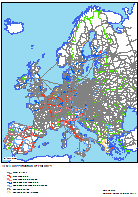
RRG GIS DatabaseTransport networks - Railway networkGeneral information The RRG European rail network layer contains all passenger and freight railway lines under operation today, and rail ferries of 38 European countries. The database contains all passenger train stations which are under operation today, plus planned (future) ones (as far as information are available) and many of those that are currently closed or abandoned. In addition, the rail network layer also includes many freight and cargo stations (such as road-rail transshipment points, ports, major industry terminals, container transshipment facilities), as well as train depots and marshalling yards. For many agglomerations tram and subway stations are coded in the database as well. Several attributes allow to differentiate the stations by station type and by special characteristics, as explained further below. Altogether, there are currently approx. 52,500 railway, tram or subway stations coded in the layer. Currently the rail network altogether contains about 85,764 links and 78,937 nodes, including tramways and subways for selected cities. In addition to currently existing rail lines, the database contains all future projects of the trans-European transport network (TETN) programme of the European Union as specified in Decision 1692/96/EC of the European Parliament and of the Council (European Communities, 1996), further specified in the TEN Implementation Report (European Commission, 1998), and later revisions of the TEN guide-lines provided by the European Commission (1999; 2002a; 2004a; 2004b), so as the revision of the TEN-T guidelines as of 2011 (European Commission, 2011a; 2011b; 2014), information on priority projects (European Commission, 1995; 2002b; 2005), as well as the so-called TINA networks (TINA = Transport infrastructure needs assessment; TINA Secretariat, 1999; 2002; Kartal, 2007) for the new member states and candidate countries and the Helsinki Corridors for the remaining east European countries. A subset of the rail network is the strategic rail network which contains the trans-European rail links specified in Decision 1692/96/EC of the European Parliament and of the Council, the TINA networks for the candidate countries and the Helsinki corridors (European Commission, 1995) for the remaining East European countries as well as selected additional links in Eastern Europe and links to guarantee connectivity of regions and centroids. The strategic rail network is dedicated as a transport modelling network, e.g. for accessibility calculations, on the European, national and regional level. For modelling purposes, it also contains virtual access or connector links linking the centroids of the transport zones to the network. The transport zones correspond to the NUTS-2 regions of the system of region as defined by Eurostat (Eurostat, 1995; 1999a; 1999b; 2004; 2007; 2010). The Trans-European Transport Outline Plan, Section Railways, and the TINA network cover not only the member states of the European Union and the new member states, but also the candidate countries and Turkey. Moreover, the Helsinki corridors extend into the remaining east European countries. In addition to the coding of the TEN-T outline plans, also other national outline plans of the European countries are coded in the rail network layer. By applying this information, future rail networks until 2030 may be extracted from the RRG GIS Database. Similar to the future developments, the rail network layer also comprises the historic development of the rail networks since 1970, which means that the development over time of the rail networks from 1970 until 2030 is coded in the database. Thus, layers representing the rail network for any of the years in between 1970 and 2030 may be provided upon request. For rail links, the database furthermore distinguishes between high-speed lines, upgraded high-speed lines and conventional lines. High-speed lines are recently built or planned tracks for a maximum speed equal to or greater than 250 km/h or average speeds between 150 and 250 km/h depending on the country and the train system. Links upgraded for high-speed are designed for speeds up to 200 km/h or average speeds between 100 and 150 km/h. All other rail links are considered conventional lines. The name of the layer containing the trans-European railway network is RAILxx and comprises arc (RAILARC) and node (RAILPNT) feature classes. Its main characteristics are: Layer name: RAILxx Feature classes: Arcs, nodes (points) No of arc features: 85,764 No of node (point) features: 78,937 User attributes associated with the arcs: 35 User attributes associated with the nodes (points): 25
Detailed description of the arc attribute table The following user-defined fields are available in the RAILARC layer for the arc feature class:
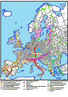
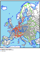
COUNTRY indicates the ISO code of the country in which the link is located. Because rail and passenger ferries cannot be assigned to any country, ferry links have the country code YY. LINKTYPE, LINKCAT, LINKUSE, OPERATION, COOKNET, TRACK, MARITIME, CLOSURE and CONST give general information on all links. COOKNET differentiates those links which are part of the Thomas Cook rail network from the other links, while CONST represents artificial buildings (constructions) along rail sections: tunnels and bridges. However, only major buildings are coded in the dataset. MARITIME gives the shipping time of ferries, in minutes. If a link is closed or abandoned, CLOSURE indicates the year when the link was closed. This information, however, is only available for a limited number of closed links. CONTINENTS provides a flag for the continent upon which a link is located, allowing the user to select all features located on a specific continent within one step. The database covers features in Europe (CONTINENTS=5), Asia (CONTINENTS=1, parts of Russia and Turkey, Syria, Lebanon, Israel, Palestine), and Africa (CONTINENTS=2, Algeria, Egypt, Tunesia, Lybia, Marocco). PATHWAY is an indicator describing the facility types that are interconnected by pathways. For instance, a pathway may connect a rail station with a tram or subway station located close by, or a pathway may interconnect two platforms of a tram station. Various combinations of connectors are possible between rail stations, tram and subway stations, and dedicated station entrances. The latter ones are always connected to the rail, tram or subway networks via pathways. This field can be used in trafic modelling to assign special impedances (such as walking times) in different modeling set ups. TENCAT, TENALIGN, PRIOEL, PRIOEU03, PRIOVM, PRIOSEC, CATEGORY, CORRDORS and EUFRANET give information on those links which are included in the Trans European Transport Network Outline Plan, Section Railways based on the Joint Decision of the European Parliament and of the Council published in the Official Journal of the European Communities (L228, 9 September 1996) or are part of the TINA network (TINA Secretariat, 1999; 2002). The railway corridors towards eastern Europe were first agreed at the second Pan-European Conference of the European Ministers of Transport in Crete in March 1994 (Crete Corridors) and secondly confirmed at the Helsinki meeting (now: Helsinki Corridors). The TINA rail link, backbone (CATEGORY=2) are the former Crete Corridors in the candidate countries, whereas the TINA rail link, additional (CATEGORY=3) represent additional links identified by the TINA Secretariat in correspondence with the candidate countries to connect important cities to the trans-European railway network. Additional links of the strategic network (CATEGORY=5) are (semi-)important rail links identified by RRG which are neither part of the TEN or TINA networks nor part of the Helsinki corridors (CATEGORY=4) but are used to guarantee connectivity of regions and centroids to the trans-European railway network. They were introduced mainly for modelling reasons. EUFRANET indicates whether or not a link is included in the so-called Dedicated Rail Freight Network as proposed by the Eufranet (2001) project. The dedicated rail freight network distinguishes between a core net-work and an intermediate network. A planned conventional line (TENCAT=6) is new conventional railway line to be constructed, that currently not exists. A planned upgraded high speed line (TENCAT=4) is currently a conventional rail line planned to be upgraded for high speed traffic in future. Similarly, an upgraded high speed line (TENCAT=3) represents a formerly conventional line that was upgraded for high speeds by technical improvements (signalling techniques, removal of level crossings etc.). A planned high speed line (TENCAT=2) is a new high speed link to be constructed that currently does not exist. Finally, a high speed line (TENCAT=1) is an existing high speed rail link constructed on separate alignment specially designed for high speed traffic. The four attributes PRIOEL, PRIOEU03, PRIOVM and PRIOSEC inform about whether or not a road section is part of the priority projects. Priority projects were first identified by the European Commission at the Essen summit (PRIOEL). These projects are part of the TEN and were considered of crucial importance for the further development of the trans-European transport networks. Hence, efforts and money was concentrated on them. The priority projects of the Essen list concentrated on the old EU member states. In 2003, the Van Miert high level group developed suggestions and recommendations for the further development of the TEN and TINA networks in general, and for the priority projects in particular. Their suggestions are laid down in PRIOVM. In the light of the enlargement of the EU, this list now extends into the new member states. However, not all of the suggestions of the Van Miert group were finally adopted by the Commission. Therefore, PRIOEU03 represents the final revised list of the rail priority projects. Parts of these priority projects are furthermore subsumed under the so-called Quick Start Programme (QSP, European Commission, 2004). These prioritised sections can be identified by querying the attribute PRIOSEC. The fields TEN2011COREP, TEN2011COREF, TEN2011CLASS and CORRIDORS2011 indicate the latest 2011 outline plans of the European Commission (DG MOVE, 2011; 2014) on the further development of the Trans-European transport networks for a regulation of the European Parliament and of the Council. These plans differentiate the TEN-T networks into so-called Freight and Passenger Core Networks (TEN2011COREF=2 and TEN2011COREP=2) and Freight and Passenger Comprehensive Networks (TEN2011COREF=1 and TEN2011COREP=1, respectively). By using TEN2011CLAS, the actual classification of the rail network into completed conventional and high-speed rail links, conventional and high-speed rail links to be upgraded and planned conventional and high-speed rail links can be differentiated. CORRIDORS2011 furthermore indicates the main transport corridors. VDE indicates those railway sections in Germany which were part of the so-called Verkehrsprojekte Deutsche Einheit (transport projects German unification) which were identified as crucial projects for the integration of the former two German states (Bundesministerium für Verkehr, Bau und Stadtentwicklung, 2012; Kieslich et al., 1992; Wikipedia, 2012). End of 2012, most of these projects were already implemented and opened to traffic. STRATEGIC indicates whether or not the link is part of the strategic rail network. The strategic rail network contains the trans-European rail links specified in Decision 1692/96/EC, the TINA networks for the candidate countries as defined by the TINA secretariat and the east European rail corridors (Helsinki Corridors) as well as selected additional links in Eastern Europe and further links which are not part of the TEN to guarantee connectivity of regions and centroids. The design principles of virtual access links in the road and railway networks are described here. The access links are functional links used for transport modelling to connect NUTS-2 region centroids to the network. Centroids represent the centres of transport analysis zones (TAZ) and are used as origins and destinations. Each centroid is connected to the real-world network via one or several access links. HSL indicates whether or not a link represents a (upgraded) high speed line (with speeds of more than 200 km/h). In this the attribute is similar to the TENCAT attribute, however, the main difference is that TENCAT is only referencing the Trans-European Rail Networks, whereas HSL is referencing the full rail network, including non-EU countries, and including sections that are not part of the TEN-Ts. Existing high speed rail lines today may represent upgraded high speed lines (HSL=1; upgraded from conventional lines) or new constructed high speed rail lines (HSL=2), specifically dedicated for high-speed operations; similarly, HSL is also referencing planned future high speed rail lines, which may either be upgraded in future (HSL=3) or may be newly constructed (HSL=4). SPEED_TT provides speeds on railway sections according to actual timetables. Often, datasets provide the maximum design speeds that can be travelled by trains along a section, however, in reality the maximum design speeds are rarely reached due to different reasons. Therefore, speeds derived from the timetables provide a more realistic picture on the speeds that are actually travelled, compared to the design speed of a rail segment. Optionally, additional fields would be available upon request which might be used for transport modelling purposes. This additional information refers to slope gradients and slope penalties by railway section. The attributes FROMELEVAT and TOELEVAT will then represent the elevation above sea level for the from-node and the to-node of a rail section and the attribute SLOPEGRADIENT will then represent the slope of the railway section and the attribute SLOPEPEN will give a penalty on travel times due to the gradient. All optional fields are derived through GIS techniques by overlaying the railway network layer with a digital terrain model. Detailed description of the node attribute table The following fields are available in the RAILPNT layer for the node feature class:
NODETYPE and NODEGROUP indicate the type of the node in the network. Centroids, border nodes, rail ferry ports, rail junctions and branchings, as well as railway, tram and subway stations and tunnel and bridge portals are differentiated. Rail nodes (NODETYPE=2) are used at locations where the characteristics of the railway tracks change (e.g. where a one track line is changing to a dual track line). NODETYPE can also be used to establish a hierarchy of railway stations: main stations (NODETYPE=5), regional train stations (NODETYPE=9), secondary passenger train stops (NODETYPE=10), freight terminals (NODETYPE=6), ferry seaports (NODETYPE=3) and stations out of operation (NODETYPE=11). However, NODETYPE reflects only the main character of a node. A node identified as railway station (NODETYPE=5) may, at the same time, also represent a rapid urban train or IC station. Therefore, the attributes ECESTAT, ICESTAT and REGSTAT provide further information on the character of a station: ECESTAT identifies stations for long distance (cross-border) trains (i.e. intercity trains, Eurocity trains), whereas ICESTAT identifies high-speed train stations, and lastly REGSTAT identifies stations with rapid regional trains. At any station, at the same time rapid regional trains, long distance (internationa) trains and high-speed trains may stop. NODEGROUP provides a more aggregated differentiation of the nodes, while distinguishing only between centroids, border nodes, rail nodes, stations and station entrances. By using NODEGROUP a general selection of all stations is much more convenient. Sometimes major stations may have different station entrances at either side of the railway line. The station entrances are modelled explicitly (NODEGROUP=4); they are linked to the station node by so-called pathways (see description of rail links feature class). Similarly, if a major station also comprise tram or subway station, the tram or subway station is linked to the train station via these pathways. By that, pathways help to model connecting times between trains, tramways and subways properly. OPERATION indicates the operation status of a station, whether the station is under operation, is being planned (or constructed), is closed or is expected to be reactivated. PNR provides a unique station node point number (in integer format), while PLATFORMS indicates the number of gates. NODEID1 is a unique identifier for each node in the network. The first three digits indicate the number of the region in which the node is located. COUNTRY1 indicates the ISO code of the country in which the node is located. REGION1 is a four-character acronym of the name of the region. The main city (not necessarily the greatest city) of each region is the centroid of the region. For each region the nodes are counted from 0000, with 0000 indicating the centroid. A full list of the region centroids can be found here in tabular format. Column 3 of this table illustrates the region name, whereas the last column indicates the name of the centroid. The 1995 NUTS 2 region code is also provided (corresponding to the REGION1 attribute) there. Furthermore, column 2 of this table also illustrates the unique region number, which corresponds to the region-ID in the NODEID1 attribute. CONTINENT indicates the name of the continent on which the rail node is located. Border nodes are nodes at national borders. At each border crossing there is a border node. Border nodes have two node numbers, country codes and region codes indicating that they belong to two different, neighouring countries. Thus, border nodes do have entries in the attributes NODEID2, COUNTRY2 and REGION2, providing the same information for the neighbouring country. In contrast, regular rail nodes have no entries in NODEID2, COUNTRY2 and REGION2. CONTINENTS provides a flag for the continent upon which a node is located, allowing the user to select all features located on a specific continent within one step. The database covers featrues in Europe (CONTINENTS=5), Asia (CONTINENTS=1, parts of Russia and Turkey, Syria, Lebanon, Israel, Palestine), and Africa (CONTINENTS=2, Algeria, Egypt, Tunesia, Lybia, Marocco). LABEL gives general information about the name/designation of a node. The label may represent the name of a station, may represent the name of a ferry port, a border crossing or the name of a region centroid. Sometimes also the name of important tunnel portals or bridges are provided. If a node represents a station, LABEL gives the name of the station. If a node represents a border node, LABEL shows a BORDER string, followed by the names of the two respective countries. If the node represents a region Centroid (NODETYPE=0) than LABEL will be constituted by the name of the centroid followed by the capital letter C (=CENTROID). For example, the Berlin centroid will be indicated like Berlin C. Sometimes, a station has different station names. In such cases the attribute NAMES_ALIAS provides such alternative node labels. For railways, the actual TEN-T programme distinguishes between passenger and freight lines, and moreover between core and comprehensive networks, resulting in different TEN-T networks such as - core passenger network (field COREPASS) - comprehensive passenger network (field COMPPASS) - core freight network (field COREFREIGHT) - comprehensive freight network (field COMPFREIGHT) The fields COREPASS, COREFREIGHT, COMPPASS and COMPFREIGHT thus indicate whether or not a rail node is located along any of these networks. Other subsets of the overall TEN-T network constitute nine different corridors, whose further development is of prime interest for the European Union. Any rail link might belong to none, to just one or to two or more of these corridors. The attribute CORRIDORS thus indicates along which corridor a rail node is located. By using these columns, one can for example query which stations belongs to which subset of the TEN-T network. Eventually, the column TEN aggregates such information allowing to identify those nodes located along any TEN-T axis from those located aside any TEN-T axis. NETTYPE indicates the type of link (network) a rail node is located along. A node may be located along a link purely used for passenger (NETTYPE=PASS) or for freight (NETTYPE=FREIGHT) services, or both (NETTYPE=PASS, FREIGHT), or may be located along a closed link (NETTYPE=CLOSED) or access link (NETTYPE=ACCESS). This field looks only at the link designation, while it does not indicate the actual node type (as the field NODETYPE does). So, NETTYPE=PAS for instance does not necessarily mean that the node is a passenger station, but it only says that the node is located along a link which is only operated by passenger trains. The node itself might nevertheless represent a junction, a tunnel or bridge portal. By querying NETTYPE, one can easily identify or select nodes that are located along a specific link type. Similar to the arc feature class, there is an optional attribute available in the node feature class that might be of interest for transport planning purposes. This attribute is called ELEVATION and represents the elevation above sea level at the node location. This attribute is derived by GIS techniques through an overlay of the railway network layer with a digital terrain model.
RRG GIS Database contents:General informationTransport networks Available transport datasets Geography Interaction data and regional data Informationen zur RRG GIS Datenbasis sind nur auf Englisch verfügbar. |
|||||||||||||||||||||||||||||||||||||||||||||||||||||||||||||||||||||||||||||||||||||||||||||||||||||||||||||||||||||||||||||||||||||||||||||||||||||||||||||||||||||||||||||||||||||||||||||||||||||||||||||||||||||||||||||||||||||||||||||||||||||||||||||||||||||||||||||||||||||||||||||||||||||||||||||||||||||||||||||||||||||||||||||||||||||||||||||||||||||||||||||||||||||||||||||||||||||||||||||||||||||||||||||||||||||||||||||||||||||||||||||||||||||||||||||||||||||||||||||||||||||||||||||||||||||||||||||||||||||||||||||
|
|||||||||||||||||||||||||||||||||||||||||||||||||||||||||||||||||||||||||||||||||||||||||||||||||||||||||||||||||||||||||||||||||||||||||||||||||||||||||||||||||||||||||||||||||||||||||||||||||||||||||||||||||||||||||||||||||||||||||||||||||||||||||||||||||||||||||||||||||||||||||||||||||||||||||||||||||||||||||||||||||||||||||||||||||||||||||||||||||||||||||||||||||||||||||||||||||||||||||||||||||||||||||||||||||||||||||||||||||||||||||||||||||||||||||||||||||||||||||||||||||||||||||||||||||||||||||||||||||||||||||||||