 |
|
RRG GIS DatabaseTransport networks - Airports of the WorldGeneral information The RRG World airport database contains 8,229 airports of international (world-wide), European and regional importance following the AOWT airport classification as well as the classification of the Trans-European Transport Network Outline Plan, Section Airports as specified in Decision 1692/96/EC of the European Parliament and of the Council European Communities, 1996), as well as airports of the so-called TINA networks (TINA = Transport infrastructure needs assessment; TINA Secretariat, 1999; 2002) for the new member states and candidate countries. In contrast to the other layers of the RRG GIS Database, the airport layers owns a world-wide coverage comprising not only airports in Europe but in all other parts of the world (Asia, Africa, North America, South America, Australia). An overview on the number of airports by country is given here. As for the other modes, there is also a subset of airports defined which are considered as strategic airports due to their significant importance for passenger and freight transport in Europe, which can be used for purposes of transport modelling. These strategic airports include all TEN and TINA airports, as well as some additional airports in remaining Europe and some smaller airports to guarantee connectivity of regions. The name of the RRG airport layer is AIRPORTS, and its main features are: Layer name: AIRPORTS Feature classes: Points No of point features: 8,229 User attributes associated with the points: 49 Detailed description of the point attribute table The following user-defined fields are available in the AIRPORTS layer:
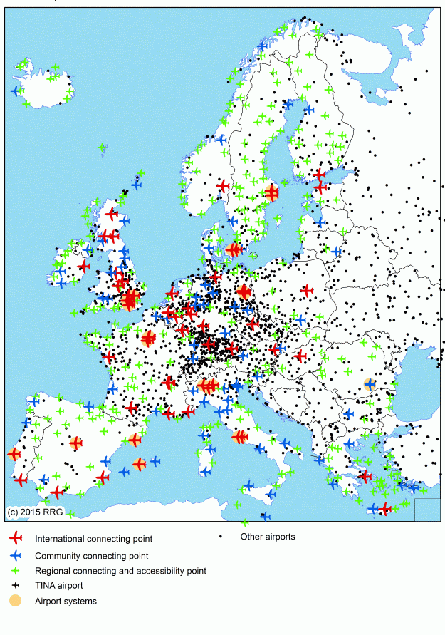
AIRPORT_NUMBER, COUNTRY, REGION, LABEL, NAME_ALIAS, OPERATION, TYPE, ELEVATION, INTERNATIONAL, AOTWH, OAG_CLASS, HUB, CONTINENT, GEOGRAPHICAL_AREA, CITYPOP_50KM, CITYPOP_100KM, TIMEZONE, IATA and ICAO give general information on all airports. AIRPORT_NUMBER is a unique identifier for all airports. COUNTRY indicates the ISO code of the country in which the airport is located. REGION is a four-character acronym of the name of the region. CONTINENT indicates the name of the continent on which the airport is located. IATA and ICAO represent the official airport codes as defined by these two airport associations. Since not all airports belong to any of these organizations, not all airports do have such codes, i.e. some airports of the database are lacking such codes. AOTWH, OAG_CLASS and HUB offer different airport classifications, which may be used for mapping or for statistical analyses. AOTWH provides a hierarchy of airports according to the Airport-of-the-world webpage. There, larger airports are differentiated from smaller scheduled passenger airports and from other airports; however, this web resource does not include all airports; therefore, another category (AOTWH=4) was added holding airports that are not listed. GEOGRAPHICAL_AREA gives the name of the larger geographical area where the airport is located. TIMEZONE represents the time zone in which he is located, expressed in number of hours (+/-) compared to Greenwhich time. CITYPOP_50KM and CITYPOP_100KM indicate the number of resident population living within 50 or 100 km distance from the airport (i.e. population or market potential). The layer not only includes airports under operation today, but also includes airports that are closed, planned or under construction; the status of the airport operation can be queried by using the OPERATION attribute. TYPE provides further information on the predominant character of the airport, whether it is an international or domestic airport, a military air base or sailplanes airfield, or whether it represents a (small) heliport. In exceptional cases also combinations of the numbers are provided (for instance 2,6 indicates a domestic airport which also hosts a heliport; another example would be 2,3 for a domestic airport with attached military airbase). However, it is worth to note that TYPE only refers to the predominant character of each airport: of course international airports will also have domestic flights, and even predominantly domestic airports may sometimes also have few individual international flights. RUNWAYS provides the number of runways for each airport, while RUNWAY_LENGTH gives the length of each runway. If an airport has got several runways, all lengths of all runways are provided here, if information is available. The structure of this string variable is as follows: First, the runway number is identified, followed by the length of that runway, enclosed in brackets; if there is a second runway, again the runway number is followed by its length, which is enclosed in bracket again. This is done similarly for all available runways. If the length of the runway is unknown, it is indicated by (-99); if the number of runways and also their lengths is not available for any airport, the attribute just indicates -99. AIRCRAFT_STANDS, TERMINALS, CARGO_TERMINALS, GATES, DESKS and BAGGAGE_CLAIMS provide detailed information on the available airport infrastructures for aircrafts, passenger and cargo handling, respectively, while HOTELS, SHORT_PARKING and LONG_PARKING indicate availability of related secondary airport infrastructures. OPERATING_HOURS indicates the airport operating times during the day. CON_DOM_DOM, CON_DOM_INT and CON_INT_INT provide information on the minimum connecting times (or changing times) for domestic-domestic flights (CON_DOM_DOM), domestic-internaitonal flights (CON_DOM_INT) and between internaitonal flights (CON_INT_INT). CAP_PASS, CAP_CARGO and CAP_WAREHOUSE give information on the maximum annual passenger and cargo and warehouse capacities, subject to the handling equipment and handling infrastructure of each airport. TRAF_PASS, TRAF_CARGO, TRAF_CARGO_LBS and TRAF_MOV list the annual number of passengers (TRAF_PASS), the annual cargo handled (TRAF_CARGO and TRAF_CARGO_LBS) and the annual number of aircraft movements (TRAF_MOV) for one or several years in a string. First, the year in question is provided, followed by the actual figures enclosed in brackets. Several years are separated by semicolons. That way for a number of airports time-series are provided with figures for several years, dating back to the mid-1990ies. TENCAT, TENAS, CATEGORY, PRIOEL, PRIOVM and STRATEGIC give information on those airports included in the TEN and TINA programmes of the European Commission, and those strategic airports used for transport modelling purposes. TENCAT differentiates airports into hierarchical classes of functional importance. TENAS indicates whether or not the air-port is part of an airport system, consisting of several airports closely located to each other with certain functional subdivision among them. Airport systems exist in the following cities: Berlin, Buccuresti, Kopenhagen-Malmø, Lisboa, London, Milan, Paris, Roma, Stock-holm, and Venezia. CATEGORY differentiates TEN and TINA airports from other strategic and non-strategic airports throughout Europe. STRATEGIC eventually differentiates those airports being part of this strategic modelling network (STRATEGIC=1) from those who do not participate (STRATEGIC=0). It is worth to note that these fields concern airports located within the territory of the European Union only. NODIRECTDEST represents the number of destinations served from that particular airport through direct scheduled flights in 2006. Only scheduled flights are considered, while charter, cargo or other flights are not counted. The timetables as of winter 2005/spring 2006 are laid down, based on information provided by the OAG (2004; 2005a; 2005b; 2006). Zero indicates that an airport did not have any scheduled flights in 2006. RAIL_CONNECT indicates whether or not an airport has railway station facilities, and if yes, which type of trains serves the airport. Rail connections are very often one of the main feeder modes for airports. Information were taken from OAG (2006), Schweers&Wall (2002; 2004; 2005a; 2005b; 2007; 2008; 2011) as well as the individual airports webpages. Apart from rail services, most of the airports are also served by direct bus and taxi services from/to city centres.
RRG GIS Database contents:General informationTransport networks Available transport datasets Geography Interaction data and regional data Informationen zur RRG GIS Datenbasis sind nur auf Englisch verfügbar. |
|||||||||||||||||||||||||||||||||||||||||||||||||||||||||||||||||||||||||||||||||||||||||||||||||||||||||||||||||||||||||||||||||||||||||||||||||||||||||||||||||||||||||||||||||||||||||||||||||||||||||||||||||||||||||||||||||||||||||||||||||||||||||||||||||||||
|
|||||||||||||||||||||||||||||||||||||||||||||||||||||||||||||||||||||||||||||||||||||||||||||||||||||||||||||||||||||||||||||||||||||||||||||||||||||||||||||||||||||||||||||||||||||||||||||||||||||||||||||||||||||||||||||||||||||||||||||||||||||||||||||||||||||