 |
|
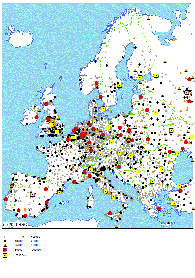
RRG GIS DatabaseGeography - Cities in EuropeGeneral information The RRG GIS city point layer provides the location and attributive information for cities in Europe. Generally, all cities with more than 50,000 inhabitants are includes, as well as all cities which are members of the Hanse (St�dtebund DIE HANSE, 2008), all cities participating in the Urban Audit programme of the European Commission (DG Regio, 2008; European Union, 2007), all cities analysed in ESPON Project 1.1.1 on urban areas as nodes in a polycentric development (Nordregio, 2004; ESPON Project 1.1.1, 2008), all cities under investigation in the RePUS project on Regional Polycentrid Urban Systems (Benini and Nali, 2007; RePUS, 2008), all cities participating in the HANSE association) (St�dtebund DIE HANSE), and all cities that represent NUTS-3 region centroids. All these cities are included in the GIS database even if they have less than 50,000 inhabitants. While the Urban Audit programme and also the ESPON Project 1.1.1 cover cities in the whole of Europe, the RePUS project is concerned with town and cities development in central-European countries like Austria, Czech Republic, Hungary, Italy, Poland, Slovakia and Slovania. Cities that are member of the Hanse association are located in Belarus, Belgium, Estonia, Finland, France, Germany, Iceland, Latvia, Lithuania, the Netherlands, Norway, Poland, Russia, Sweden and the UK. Altogether, 4,655 cities for the whole of Europe are available. This layer can be used just for mapping purposes or as points of interest, but can also be used for specific analytical purposes. The basic features of this layer are: Layer name: CITIES Feature classes: Points No of point features: 4,655 User attributes associated with the points: 31 Detailed description of the point attribute table The following user-defined attributes are available in the CITIES layer for the point feature class:
POINTID represents a unique point ID, with x.0000 representing the capital city (x = country ID). The POINTIDs of those cities that at the same time represent NUTS-2, NUTS-1 or NUTS-0 region centroids are identical to the POINTIDs in the NUTS0CENT or NUTS1CENT or NUTS2CENT layers. LABEL gives the name of the city. TYPE hierarchically differentiates the capital cities, NUTS-1 region, NUTS-2 region and NUTS-3 region centroids from the other cities. Higher level centroids are always centroids of the lower level, i.e. a NUTS-2 region centroid is always also a NUTS-3 region centroid; similarly, a NUTS-1 region centroid represents at the same time a NUTS-2 region centroid. COUNTRY indicates the ISO country code of the country in which the city is located, whereas NUTS1_CODE, NUTS2_CODE and NUTS3_CODE provide the official NUTS-1, NUTS-2 and NUTS-3 region codes as published by Eurostat in which the city is located. POPCITY, POPAGG, POPNUTS3, POPNUTS2, POPNUTS1 and POPCOUNT provide actual population figures for the city (POPCITY), the entire agglomeration area (POPAGG), for the respective NUTS-3 (POPNUTS3), NUTS-2 (POPNUTS2) and NUTS-1 regions (POPNUTS1) and for the overall country (POPCOUNT). If a city does not constitute a greater agglomeration area, then the population figures provided in POPAGG and POPCITY are identical. HANSE is indicating whether or not a city is member of the Hanseatic League, which is the newly revived city network of towns and cities in northern Europe trying to keep alive and promote the cities as a place to life and a place for culture. It dates back to the 'old' HANSE network of cities which reached their greatest influence during the 16th and 17th centuries with strong political and commercial power (for more information visit the HANSE webpage). FUA_ID, FUA_TYPE, REPUS_ID and REPUS_TYPE provide information on those cities participating in the ESPON Project 1.1.1 or Re-PUS project. FUA_ID and REPUS_ID provide the respective city codes or city number, which can be used to link additional information from the projects to the cities. FUA_TYPE and REPUS_TYPE represent the city classification, or city typologies, which were elaborated in the ESPON 1.1.1 and RePUS projects. UA_CODE and Urban_Audit indicate whether a city participates in the Urban Audit (UA) programme. While UA_CODE gives the respective UA city code, Urban_Audit indicates the year since which the city participates. Many cities in Europe restrict car traffic in urban centers. UAR_TYPE, UAR_YEAR and UAR_WEB give information about these urban access restrictions by type of restriction (UAR_TYPE), the year when these access restrictions were first introduced (UAR_YEAR) and a hyperlink to obtain more information (UA_WEB). TEN_T_NODE indicates whether a city represents a node in the TEN-T core network (as defined in European Union regulation 1315/2013). Three fields provide information about the European Capitals of Culture. ECC_TYPE indicates whether a city was a capital of culture and what type of city it then was. ECC_YEAR gives the respective year, and finally ECC_FINANCE roughly indicates the budget spent to be a European Capital of Culture. Some fields provide information about the infrastructures available in a city. LNG_FLEET identifies cities owning an LNG bus fleet (so far only Swedish cities considered). METRO indicates whether the city has a metro system, while TRAM indicates whether the city has a tram system (with STADTBAHN as a specific tram system that partially operates in the underground); PORT indicates whether the city has a commercial inland or seaport (or both); and finally AIRPORT indicates whether the city has a commercial airport in its vicinity. X-COORD and Y-COORD give the geographical position of the city centre.
RRG GIS Database contents:General informationTransport networks Region boundaries, admninistrative boundaries Geography Available geographic datasets Informationen zur RRG GIS Datenbasis sind nur auf Englisch verfügbar. |
||||||||||||||||||||||||||||||||||||||||||||||||||||||||||||||||||||||||||||||||||||||||||||||||||||||||||||||||||||||||||||||||||||||||||||||||||||||||||||||||||||||||||||||||||||||||||||||||||||||||||||||||||||||||||||||||||||||||||||||||||||||||||||||||||||||||||||||||
|
||||||||||||||||||||||||||||||||||||||||||||||||||||||||||||||||||||||||||||||||||||||||||||||||||||||||||||||||||||||||||||||||||||||||||||||||||||||||||||||||||||||||||||||||||||||||||||||||||||||||||||||||||||||||||||||||||||||||||||||||||||||||||||||||||||||||||||||||