 |
|
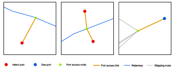
RRG GIS DatabasePort access linksThe node representing the seaport or inland port is connected to the real-world waterway network using virtual port access links (LINKTYPE=5). The port node can be identified using the NODETYPE attribute of the NAT (NODETYPE=4, NODETYPE=14 or NODETYPE=17). The node to which the port access link connects to the real-world waterways is considered a so-called port access node (NODETYPE=12). The figure below gives a schematic demonstration of this database design principle. One port access node can be the gateway for one (left) or for two or more port access links (for instance, if two ports are located on opposite sides of the waterway) (middle), and can be the gateway for either inland ports or seaport (right). In contrast to the waterway network, the road and rail networks do not contain port access links, but virtual centroids and access links.
RRG GIS Database contents:General informationTransport networks Region boundaries, admninistrative boundaries Geography Interaction data and regional data Informationen zur RRG GIS Datenbasis sind nur auf Englisch verfügbar. |
|||||||||
|
|||||||||