 |
|
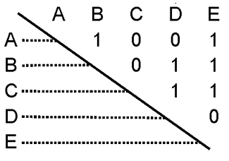
RRG GIS DatabaseInteraction data and regional data - Neighbourhood matricesNeighbourhood matrices indicate whether or not regions are neighbouring each other. The neighbourhood matrices are available in binary format, i.e. ‘1’ indicates that two particular regions are neighbours, whereas ‘0’ indicates that they are not neighbouring each other.Neighbourhood matrices can be generated for different statistical levels, from NUTS 0 level (i.e. country level) to NUTS 5 level (i.e. municipality level). Upon request such matrices can also be generated for specific systems of regions.
RRG GIS Database contents:General informationTransport networks Region boundaries, admninistrative boundaries Geography Interaction data and regional data Introduction |
|||||||||
|
|||||||||